|
 The project idea originates from the understanding that earlier watershed interventions continued to be patchy as the focus remained on individual households, rather than on an area. It was felt that there is an immediate need to implement the very concept of watershed and its imperatives such as comprehensive, ridge to valley treatments, hydrological considerations in treatment measures. Broadly a "watershed approach" is essential as management of rainwater over time and across space affects the production frontier or carrying capacity and its sustainability due to the terrain. The project idea originates from the understanding that earlier watershed interventions continued to be patchy as the focus remained on individual households, rather than on an area. It was felt that there is an immediate need to implement the very concept of watershed and its imperatives such as comprehensive, ridge to valley treatments, hydrological considerations in treatment measures. Broadly a "watershed approach" is essential as management of rainwater over time and across space affects the production frontier or carrying capacity and its sustainability due to the terrain.
|  |
It is understood that public investments through MGNREGA can accelerate the pace of development in areas broadly coming under Jungle Mahal of West Bengal. |
The population in the project area is predominantly rural with over 90% live in villages. A vast majority of small / marginal farmers in the region would be keen to develop their farms and water bodies. Further, a large majority of SC and ST households would look forward to gain employment under MGNREGA. A major part of the region falls under the sub-basin of the river systems formed by Dwarkeshwar-Shilabati and Kangsabati rivers. These three rivers and their tributaries drain off about 80% of water from the region. The target region forms the lowest ridges of the Chotanagpur Plateau characterised by rolling topography with intermittent sharp undulations or hill formations. About 23% of the total area is under forest cover. Region receives 1000 to 1400 mm of rainfall annually. An overwhelming majority of the population earn their living from Agriculture. Farming is predominantly rain fed with only 16% of the Net Sown Area under irrigation. About 45% of rural households in the region belong to BPL category with high incidences of poverty among ST and SC communities
|
|
 150 macro-watersheds or 1500 Micro-watersheds amounting to an estimated 7.50 Lakh ha. of catchments in the upper ridges would be treated under the proposed project. Livelihoods of approximately 5 Lakhs households will be positively impacted by the treatments. Out of this about 80% households belong to ST, SC and OBC Communities. Treatment measures would be undertaken to improve the hydrology of the area, thereby triggering growth in farming. Considering the vast number of `job seekers' in the region already enlisted under MGNREGA, the State may complete the treatments in the next 5-7 years. 150 macro-watersheds or 1500 Micro-watersheds amounting to an estimated 7.50 Lakh ha. of catchments in the upper ridges would be treated under the proposed project. Livelihoods of approximately 5 Lakhs households will be positively impacted by the treatments. Out of this about 80% households belong to ST, SC and OBC Communities. Treatment measures would be undertaken to improve the hydrology of the area, thereby triggering growth in farming. Considering the vast number of `job seekers' in the region already enlisted under MGNREGA, the State may complete the treatments in the next 5-7 years.
|
| |
Salient features of the project area:
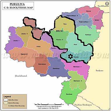
The project called "Watershed Based Treatment of River Basins of Jungle mahal Region of West Bengal" uniquely focuses on Western Plateau and High Lands regions of the State, comprising of the entire district of Purulia, large parts of West-Midnapore and Bankura districts and small parts of Bardhaman and Birbhum districts. This region forms the lowest ridges of the Chotanagpur Plateau characterised by rolling topography with intermittent sharp undulations or hill formations. A major part constitutes the Jungle Mahal region. About 23% of the total area is under forest cover.
|
| |
Overall objective of the project: |
.gif) The main objective of the project is to maximize present and future benefits for the largest number of people, especially poor people, who depend on natural resources. The main objective of the project is to maximize present and future benefits for the largest number of people, especially poor people, who depend on natural resources.
Restoration of degraded land and soil enrichment
In-situ water harvesting
Conversion of agriculturally marginal lands to appropriate land use
To reduce the impacts of climate variations and to make the communities climate resilient
Adoption of improved farm management practices (e.g. practice of water recycling, green manuring etc.)
Intensification and diversification of farming that would promote prosperity and enhanced human conditions
The project is estimated to cover around 7.50 Lakh ha. of catchments in the upper ridges under the mega-watershed approach
|
| |
Major deliverables of the project: |
The main objective of the project is to maximize present and future benefits for the largest number of people, especially poor people, who depend on natural resources.
Restoration of over 4 lakh ha. of upland areas, checking soil erosion, reducing run off by at least 50%.
An increased flow in rivers and rivulets in the sub-basin areas and prolonging of water flow in the downstream areas at least by 3-additional months.
At least 50% area (3.50 Lakh ha.) would be covered under 150% to 200% cropping intensity.
Significant reduction in impacts of climate variations
Economic vibrancy and emergence of multiple options of employment for young women and men
At least 50% increase in income (from the current level) at household level.
Enhanced social capital - Community collectives, progressive farmers, agro- entrepreneurs etc.
Strong and mutual relationship among People, PRI and Public Systems
|
| |
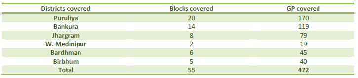
Project area: |
Project would focus primarily in the districts listed below: |
|
| |
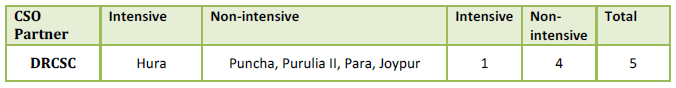
Project location - (DRCSC's Coverage): |
Project would focus primarily in the districts listed below: |
|